Vogelsang Peak, Mount Florence7-Jul-04By: Ed Lubin |

|
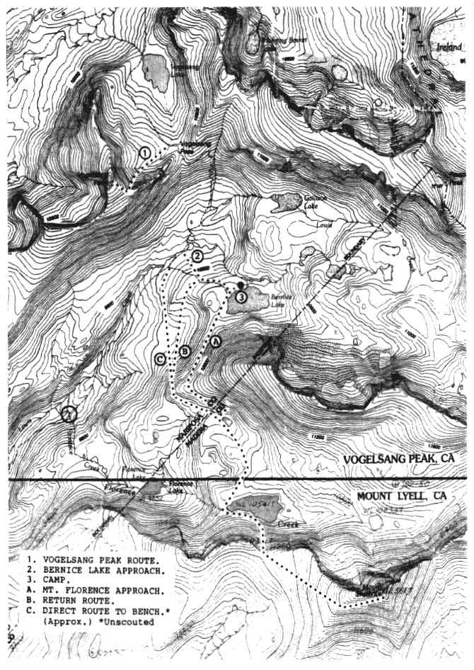
VOGELSANG PEAK By east face left side gully route
MT. FLORENCE By Bernice Lake exploratory routes Climbing team members for Vogelsang Peak (11,516') in Yosemite National Park were Doris Gilbert, Jack Barrett, George Denny, Vance Handley and myself. Only Vance and I attempted Mt. Florence (12,561 '). The 7.5' quadrangle maps used were: Vogelsang Peak, CA, and Mount Lyell, CA. George backpacked to Fletcher Lake adjacent to Vogelsang High Sierra Camp, Tuesday, July 7th~* The rest of us stayed at Tuolumne Meadows High Sierra Camp that night, which cost $96.00 for a four person tent cabin, towels and shower facilities included. We had dinner and breakfast there. Tel. (209) 372 8413. From the Dog Lake parking lot near Tuolumne Meadows High Sierra Camp, we connected with the John Muir Trail, then Rafferty Creek Trail, as we backpacked to Fletcher Lake on Wednesday, making camp with George. There are bear boxes for campers to use and we also had canisters, but two bags of trail mix were accidentally left in one of our backpacks. The resident bear had a real treat that night. The only damage to the open, in mint-condition, classic Kelty, was a torn baffle. On Thursday, with Vance and I backpacking, the five of us took the Vogelsang Pass Trail up to the tiny snow-fed rivulet at the base of the east ridge of Vogelsang Peak, the beginning of our climb. Doris had found the route information on Summitpost.org. The route took us below the east ridge, up a snow filled couloir and onto a short pitch of class 3 rock at the summit. It was a delightful climb with exceptional views, including those of Half Dome and Clouds Rest. (Trekking poles without snow baskets were used. Depending on snow conditions an ice axe and crampons could be needed.) We separated back down on the Vogelsang Pass Trail. George, Jack and Doris first went the short distance to the Pass for the sublime view; then they returned to Fletcher Lake to backpack out on Friday. Doris had made telephone reservations for Jack and her to have dinner and breakfast at Vogelsang High Sierra Camp, $50.00 per person. She later said the meals were excellent. Vance and I headed south over Vogelsang Pass, down the Lewis Creek Trail, destination Bernice Lake. We were seeking to fmd a more direct route to Mt. Florence, with less distance and gain than any documented one known by me, including Florence Creek. Bernice Lake is in a beautiful setting, and can be reached in slightly less distance than on trail, by heading uphill just beyond where Lewis Creek Trail crosses the outlet stream. We had the lake to ourselves for two of our three nights there - except for mosquitoes. We scouted the initial part of our exploratory route on Friday; then I went fishing, which was good for ten inch Brookies using spinners. Believing that my fishing rod was lost, one of my trekking poles was utilized. I keep about three feet of duct tape wrapped around the right pole to easily identify it from left, and for certain types of repairs. A few inches was used to join the spinning reel to the pole. A hole for the line was fashioned by bridging the wide, round-bottomed slot in the poles basket, also with duct tape! Good casts could be made with the contraption. My rod turned up after fishing. The couple of trout not released by me were prepared for dinner by cutting them into small pieces (small pot) sealing in foil, and cooking for about twenty minutes in boiling water. The trout was good, but with seasoning it would have tasted even better. Vance's Alpine Aire freeze-dried Potatoes and Cheddar with Chives, combined well. Traveling at a slow to moderate pace we started for Mt. Florence at 8:00 a.m. on Saturday. We traversed very gradually up to the crest of the ridge south of Bernice Lake; at first on smooth terrain, then talus for much less distance than expected, then on scree. We continued contouring up on the south side of the ridge to about 10,600 feet, seeking a way down the unexpected cliff beneath us. The band of cliff is mainly composed of large sheets of smooth granite inclined roughly, sixty degrees. Our descent route of about 200 feet to the small unnamed lake at the cliff base, was the only questionable part of our peak approach, intended to be no higher than class 3. An easier way down the formation may exist. From the cliff we went toward the couloir on the south side of Lake 10,541', located above Florence Lake. At that lake we converged with the Florence Creek approach to Mt. Florence. We were 3 brs 10 minutes from camp, and took a thirty minute break to rest and eat. There is large talus solidly lining the south shore of the lake, and up the whole couloir. The scree at the saddle soon gave way to big talus as we climbed toward the summit. The talus extended clear to the Southwest Ridge of Mt. Florence, was unexpected, and slowed our progress even more. At 6 hrs 45 minutes from camp, only about 800 vertical feet and one-half mile short of our goal, we stopped. After taking 45 minute to rest and feel the serenity, we headed down at 3:30 p.m. We switchbacked down a band of snow in the couloir, using our trekking poles for aid, and retraced our route to the small unnamed lake near the base of the aforementioned ridge cliff band. Instead of attempting to climb the cliff by our descent route or fmd another way up, we used our planned alternate approach to the peak in reverse. Hugging the cliff, we hiked west to the base of ridge buttress, then contoured down to the northern end of the bench below it and Bernice Lake, dropping, altogether, about 600 feet. We then continued north gradually up to the Bernice Lake Trail, reaching it at 9:00 p.m. at dark. We were in camp 13 hrs 10 minutes after leaving. Planning such a late start had cost us the peak, but it still was an enjoyable day.
1. The feature of approach (A) is camping at forested Bernice Lake.
A huge helicopter had landed in the meadow early evening to evacuate an injured person. I do not know the circumstances. Fletcher Peak is popular for technical climbing. Our backpack out at a quick pace on Monday, took 3 hrs, 45 minutes. For us the weather had been ideal; but we spoke with a naturalist on the way out who told us current studies have indicated that pika in the Park had moved to a higher habitat. The previous study was made in 1914. Global warming? We showered at Toulumne Meadows High Sierra Camp (hours limited) and very refreshed, headed home, briefly stopping for lunch in the Mobil Station restaurant located at Tioga Pass Road and Hwy 395; amazingly good food for a gas station in the middle of nowhere. *"Upper" Fletcher Lake on the 15' Tuolumne Meadows Quad., and in at least one guide book.
| |
| SPS Trip Report Index | Sierra Peaks Section Home Page | |