IN HIGH PLACES: THE BENELUX COUNTRIESLuxembourgh’s Burrigplatz,
Beligum’s Botrange,
and The Netherland’s
|
 |
|||
| |
||||
In
June of 1993, my wife Jo
and I set off on one of our
best trips ever. This
is a belated reminiscence
of that memorable summer.
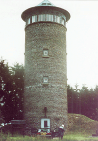
Before leaving Iceland, however, which we did the following morning, it should be noted that in good weather the country’s 6,950’high point, Hvannadalshnukur, would make a nice climb. On our attempt the prior year, we had successfully conquered its rocky southern slope, crossed the crevasse field along the crater’s rim, and were making our way across its ice-filled crater itself, a mere two miles from and only five or six hundred feet below the summit, when we were hit by a sudden storm. Although we waited three hours for the weather to break, we finally had to give it up and turn back. Since I plan to return to bag the peak, I’ll write up the details of the climb at another time. As compared to most major European gateway cities, arrival in Luxembourg is a quiet, laid-back affair. We zipped through immigration and customs, picked up our rental car with ease, and then drove 37 miles north to the town of Clervaux, set in a heavily-forested bend in a river, where we holed up for the night in a hotel room equipped with a Jacuzzi. The next morning, June 26, we continued on about as far north as possible in Luxembourg, making our first stop at Burrigplatz, where next to a brick tower with a conical roof, we found a wooden sign proclaiming, “Point Culminant Du Grand-Duche—558.35 M” (1,831’). And thus little Luxembourg—a mere nine-hundred and ninety-nine square miles in area, a third of which is forested, with a population of slightly less than four hundred thousand, most of whom speak Letzeburgesch, a dialect closely related to German—became the first of our three high points for the day. Although it had begun to rain, we were in exceedingly good spirits as we sallied forth north into Belgium. Botrange, the 694 M (2,274’) high point of Belgium, is located in that country’s eastern extremes, very close to the German border. While it’s possible to park off the main highway N68 (across the street from the Barque Michael café), about halfway between the towns of Malmedy and Eupen, and take a 4-kilometer hike through the countryside to the high point, Jo and I, because
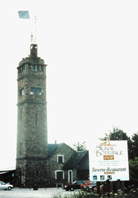
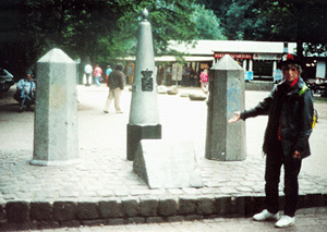
Heading north once more, we stopped about 2 p.m. at a small hotel outside of Eupen, where for a huge price in those days, Jo had a dish of celery soup, while I scarfed down the lunch special consisting of soup, fish, and a suitably rich Belgian dessert. Entering the Netherlands after lunch, we opted for a series of back roads to avoid the traffic created by the nearby industrial German city of Aachen. Coming at last to a sign reading “Drielandenpunt” just north of Vaals, we turned up a road leading to a large garden restaurant set amid a pine forest, where I pulled into a pay parking lot. We then strolled over to three small monuments indicating we were, indeed, at the Netherlands’s 322 M (1,057’) highpoint, Drielandenpunt. Three in one day, oh yeah! As a note of interest, this area is in the foothills of the Ardenne Mountains, where the Battle of the Bulge, one of the most important and vicious conflicts of WWII, occurred. Next to the highpoint is a tower which purportedly offers a fine view of the entire area, including the nearby point where the borders of Netherlands, Belgium and Germany meet. Jo and I attempted to climb the tower, but were turned back at the admission gate because we had only American currency (we’d used the last of our European currency earlier at a pay restroom). That was not the worst part, however. The worst part came when I tried to get out of the parking lot. It turns out that there was no attendant, only a coin payment box, and there I was with no change. I reparked the car and went into a nearby souvenir shop with the intent of changing a few dollars.
With slightly bruised egos, we continued on to Maastrict, where we were unable to find a hotel with a decent bed (the one hotel with a vacancy had beds that were way too soft). Fortunately, a friendly front desk clerk advised us that we might consider traveling on to the small town of Thorn, where he thought good accommodations might still be available. And that was the best tip of the trip. Thorn, it turns out, is a quaint village in which all the 18th Century buildings have been painted white—something to do with the fact that it was once run by a governing body of women. Upon arriving there, we discovered that the only room available was the honeymoon suite at the La Ville Blanche Hotel, however the accommodating manager let us have for the standard price of a double. After freshening up, we repaired to hotel’s dining room, where we enjoyed an excellent meal consisting of fresh salmon and just-picked white asparagus, both of which were covered in a marvelous home-made hollandaise sauce. And after dinner, we strolled way out into the surrounding countryside, where, even though it was past 10 p.m., the fields were still bathed in the golden glow of a northern European twilight. The next day, we drove northeast through the summer-lush countryside of Holland’s Lowlands into Germany, where we stopped for the night on outskirts of Hamburg. The following morning, we continued north into the Jutland Peninsula, where in the early afternoon, near the town of Skanderborg, amid rolling fields and farms, we found Yding Skovhoj, an undeveloped site, continental Denmark’s 173 m (568’) high point (maybe). In a situation akin to that of Delaware, however, where a trailer park near Ebright Azimuth, the State’s recognized high point, is actually higher but apparently man-made, there seems to be an argument regarding this claim. Indeed, a hill about a half mile away from Yding Skovhoj, the 170.95 M (560’) Ejer Bavnehoj, on which a red-brick building sporting a large Danish flag stands, claims to be the legitimate natural highpoint. I don’t know—visit them both. Another consideration is that Denmark also possesses Greenland, where, of course, there are real mountains. So where is the true country highpoint? Since it’s unlikely that I’ll ever get to Greenland, I’m claiming Yding Skovhoj is the real thing, and I proudly display the country’s handsome flag, a white cross on a red field, among my collection of high point banners. Jo and I continued on the Copenhagen that afternoon, and the next day we embarked on a 10-day cruise on the Baltic Sea. | ||||
| SPS Trip Report Index | Sierra Peaks Section Home Page | ||||