Participants: Patty Rambert,
Ron Hudson, Bill Livingston,
Jennie Thomas, Stephanie
Glyden, Daryn Dodge
[Note: This
trip report was written
prior to the tragic accident
on Mt. Mendel. It
was the last climb I did
with Patty and will always
remember it. The Sierras
won’t be the same without
her. (Daryn Dodge]
Earlier this
year, Patty and I compared
notes about which peaks
we lacked in common. Homers Nose
was at the top of the list. I
was intrigued by Steve Eckert’s
2005 write-up on climber.org
that establishes a variation
of the old abandoned Coffeepot
Canyon trail, which starts
near road’s end of
the Kaweah South Fork. Attempting
to strictly follow old trail
is notorious for it’s
impenetrable brush and
has only been undertaken
by strong climbers with
a 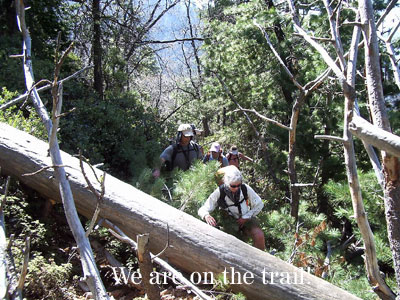 streak of masochism (Hmmm,
that’s
just about every climber
I know). Steve’s
route avoided much of the
dense bush early on, making
it a much more reasonable
dayhike possibility.
streak of masochism (Hmmm,
that’s
just about every climber
I know). Steve’s
route avoided much of the
dense bush early on, making
it a much more reasonable
dayhike possibility.
The week
before the attempt on Homers
Nose, several other people
expressed interest in joining
Patty and I. In
fact, we seemed to add one
person daily to the trip
right up to the day before. My
scary e-messages about
6000+ feet of gain, making
tired people stop and wait,
difficult navigation, limitless
bushwhacking opportunities,
and finishing after dark
did not seem to frighten
anyone except myself, so
how could Patty and I turn
them down!
On Saturday
morning, everyone was ready
for a 6 am start. Susan
Livingston and Kaweah the
Dog join us for the 3/4 mile. We
walked straight out of the
South Fork campground (which
seemed barely maintained
by the Park Service) to the
Ladybug trailhead only a
few hundred feet away at
the end of the road. We
followed the trail almost
immediately over a footbridge
that crossed the absolutely
raging South Fork of the
Kaweah. We soon came
to the small Pigeon Creek
crossing and started up the
creek bed, which was dry
down by the trail (but was
running just a hundred yards
up the creek). Using
Steve’s trip write-up
and GPS waypoints, we walked
in or beside the creek bed
until reaching a very large,
overhanging boulder. We
passed other very large overhanging
boulders along the way, but
were able to identify the
right one with Steve’s
GPS coordinates. Up
to this point, the brush
was not very dense and easy
to plunge through. Patches
of poison oak was encountered
in or near the creek bed
but were mostly knee-high
and appeared somewhat anemic. It
was not like the huge luxurious
poison oak bushes one can
find in the Santa Cruz Mountains
near where I used to live. I
suspect the higher altitudes
do not make an ideal habitat
for poison oak. Even
so, occasional patches of
poison oak were thick enough
to make it hard to avoid. Our
route stayed up on the
west side of the creek
after passing the big boulder,
following occasional vague
animal trails until a large
grassy slope can be detected
through the trees and brush.
Our group
then broke out of the trees
and brush onto this wonderful,
steep grassy slope just
east of Point 5124. 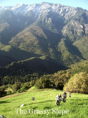 The wide-ranging
views were magnificent. None
of the other slopes around
us had anything even close
to this large a grassy slope. Moving
upwards through occasional
stands of oak trees, we eventually
arrived on the ridge top
where the steep slope lessened
considerably. If one
was lucky, one could pick-up
the old trail near here,
which runs along the northeast
side of the ridge. We
were not so lucky. We
followed the ridge on whatever
side looked less brushy,
but still ended up bushwhacking
through a section of particularly
dense class 3 brush (i.e.,
stands of brush too dense
and dangerous to walk through;
serious scratches on exposed
skin possible). Fortunately,
it lasted only a few hundred
feet until we were able to
pick-up an animal trail. This
trail seemed to eventually
run into the main trail as
it passed over the top of
the ridge we were on. It
is crucial to pick up the
trial here because the next
half-mile contours through
the worst brushy section
of the climb. The trail
is moderately obscured by
overgrowing brush, but is
easy enough to follow. However,
because of the heavy overgrowth,
don’t expect to be
able to attain even close
to normal trail speeds. Ron
made the comment that a
fire is needed (caused
by a natural lightning
strike, of course) to clear
away this brush and make
the trail more usable.
The wide-ranging
views were magnificent. None
of the other slopes around
us had anything even close
to this large a grassy slope. Moving
upwards through occasional
stands of oak trees, we eventually
arrived on the ridge top
where the steep slope lessened
considerably. If one
was lucky, one could pick-up
the old trail near here,
which runs along the northeast
side of the ridge. We
were not so lucky. We
followed the ridge on whatever
side looked less brushy,
but still ended up bushwhacking
through a section of particularly
dense class 3 brush (i.e.,
stands of brush too dense
and dangerous to walk through;
serious scratches on exposed
skin possible). Fortunately,
it lasted only a few hundred
feet until we were able to
pick-up an animal trail. This
trail seemed to eventually
run into the main trail as
it passed over the top of
the ridge we were on. It
is crucial to pick up the
trial here because the next
half-mile contours through
the worst brushy section
of the climb. The trail
is moderately obscured by
overgrowing brush, but is
easy enough to follow. However,
because of the heavy overgrowth,
don’t expect to be
able to attain even close
to normal trail speeds. Ron
made the comment that a
fire is needed (caused
by a natural lightning
strike, of course) to clear
away this brush and make
the trail more usable.
The trail
led over the next ridge
and then down to shaded
Bennett Creek, the only
flat camping area on the
trail until Salt Creek
Ridge. After
a short break and a scrub
down in the creek to remove
poison oak oils, we located
the trail on the other side
of the creek and followed
it for one or two switchbacks. We
soon lost it in brush and
headed straight up the slope
instead for a few hundred
feet until we found the trail
again zagging in a north-westerly
direction. With Ron
leading, our group continued
on the trail as contoured
slightly uphill towards Salt
Creek Ridge. Considerable
overgrowth and downed trees
slowed progress to the point
that staying on the trail
was not much of an improvement
over simply hiking cross-country. Near
the end of the trails’ north-westward
march, we decided to go straight
up to Salt Creek Ridge in
a more forested area of the
slope. The more
heavily forested sections
of the route have much
less brush to whack at.
We reached
the ridge just west of
Point 7163 and then headed
east up the ridge mostly
on the south side, only
moving to its north side
when we encountered too
much brush. Above
8000 feet, the steep hard
snow on the north side kept
us on the top of the ridge
or on the south side. We
hit a few dense manzanita
patches on the south side
of the ridge. Those
of us hiking in shorts paid
dearly; manzanita is just
awful on bare legs. The
last 300 feet to the dome-like
summit was on snow. Our strong
group reached the top together
at 2 pm and enjoyed the first
extended break since Bennett
Creek. I have to say
I was really impressed how
great of shape everyone was
in for this long climb this
early in the year. This
being mid-May in a high
snow year, the view was
of a Sierra still appearing
to be locked in winter
conditions.
We were the
first group to reach the
summit in 2006, and only
two groups had been here
in the last year since
Steve Eckert wrote his
trip report. Bob Burd and
Matthew Holliman were here
on Nov. 11th, probably dayhiking
Homers Nose from downtown
Visalia. Well, that
may be a slight exaggeration,
but not by much. Just
about every peak in the Sierras
is only a dayhike away for
those two. Surprisingly,
the earliest entry in the
register was an SPS group
on Oct. 23rd, 1955 led by
Frank Sanborn. The
SPS had only been officially
recognized as a club 1 week
prior to this 1955 climb,
but there is no historical
information about this particular
trip. Must have been
another early ‘rogue’ SC
climb. So our ascent
became somewhat a celebration
of the SPS’s 50th
(and 51st) year.
We left the
summit after only half-an-hour,
aware that we might be
returning near dark. The descent
of Salt Creek 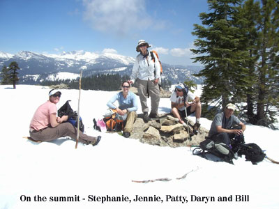 Ridge went
better, avoiding the nasty
patches of manzanita. We
dropped off the ridge at
a saddle just east of Point
7163. Heading down,
we eventually found the trail
and followed it east to a
point about 100-200 feet
from Bennett Creek where
it disappeared into brush. Staying
somewhat close to the creek,
Ron led us straight down
through some moderately brushy
areas and met up with the
trail again near where it
crossed the creek. Finding
the trail here is another
crucial point because the
upcoming brush surrounding
what’s left of the
trail is nearly impenetrable. A
little beyond the creek Ron
spotted a few sequoia trees
we had missed on our way
in. We were able to
follow the trail this time
all the way to the grassy
slope, but I headed down
the slope a little too far
to the right towards Point
5124. It got really
steep, so we contoured back
left. Back at Pigeon
Creek, we stormed down the
creek bed as darkness descended
on us and headlamps came
out. No one really
gave much thought to stomping
through the poison oak at
this point. We reached
the campground at 8:30 pm,
making for a 14.5 hour day. The
odyssey to Homers Nose
and back was a resounding
success!
Ridge went
better, avoiding the nasty
patches of manzanita. We
dropped off the ridge at
a saddle just east of Point
7163. Heading down,
we eventually found the trail
and followed it east to a
point about 100-200 feet
from Bennett Creek where
it disappeared into brush. Staying
somewhat close to the creek,
Ron led us straight down
through some moderately brushy
areas and met up with the
trail again near where it
crossed the creek. Finding
the trail here is another
crucial point because the
upcoming brush surrounding
what’s left of the
trail is nearly impenetrable. A
little beyond the creek Ron
spotted a few sequoia trees
we had missed on our way
in. We were able to
follow the trail this time
all the way to the grassy
slope, but I headed down
the slope a little too far
to the right towards Point
5124. It got really
steep, so we contoured back
left. Back at Pigeon
Creek, we stormed down the
creek bed as darkness descended
on us and headlamps came
out. No one really
gave much thought to stomping
through the poison oak at
this point. We reached
the campground at 8:30 pm,
making for a 14.5 hour day. The
odyssey to Homers Nose
and back was a resounding
success!
Special thanks
to Ron Hudson for his excellent
navigational skills. This was Ron’s
first Sierra hike since his
ankle injury at the beginning
of the year. Also,
thanks to Bill Livingston
for keeping us on track with
his GPS. Finally, thanks
to Steve Eckert for posting
his route variation, which
made a difficult dayhike
more doable. His
detailed Homers Nose trip
report can be found at:
http://www.climber.org/TripReports/2005/1394.html
